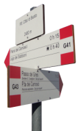
Wie kommt man zur Città di Busto

Von der Schweiz:
Auto:
bis Nufenenpass oder Beginn der Altstafel Seilbahnstationsstrasse. Siehe Karte hier .
Postauto (Bus):
Fang 111 von Airolo oder Ulrichen zum Nufenenpass. Zug- und Busfahrpläne .
Zu Fuβ:
Von der Schweiz durch den Griespass.
via Bettelmatt:
Simple trail with descend towards Bettelmatt Alpine pasture.
Download the map Download GPS route
- Routen-nummern
40-G00 + G41
- Dauer
4h
- Schwierigkeit
T2
- Auf-/Abstiege
↑ 840m - ↓ 420m
- Länge
8.3 km
via Sentiero Castiglioni:
Trail recommended only for expert hikers. Professional show gear might be required to cross steep avalanches chutes.
Download the map Download GPS route
- Routen-nummern
40-G00 + G43
- Dauer
3h20m
- Schwierigkeit
T3
- Auf-/Abstiege
↑ 690m - ↓ 300m
- Länge
7 km
Von der Italien:
Auto:
bis Diga di Morasco (VB) Italy
Bus:
Fang bus "Domodossola-Cascata Toce/Ponte" von Domodossola Bahnhof. fahrplan um https://www.comazzibus.com/eng/linee_orari.php
via Bettelmatt:
Simpler and scenic trail crossing the Bettelmatt's Alpine pasture.
Download the map Download GPS route
- Routen-nummern
G00 + G41
- Dauer
2h30m
- Schwierigkeit
T2
- Auf-/Abstiege
↑ 700m
- Länge
6 km
via Canalone di Morasco:
More challenging trail with steeper parts.
Download the map Download GPS route
- Routen-nummern
G00 + G39
- Dauer
2h10m
- Schwierigkeit
T2
- Auf-/Abstiege
↑ 700m
- Länge
5 km