HOW TO REACH US
From Italy:
By car:
Follow directions for Riale (VB) 28863 Italy and proceed to reach the base of the Morasco's Dam.
NOTE: The last part of the road is subject to closures in some periods of the summer season due to events or when the parking reaches capacity. Plenty of parking can be found along the road between the "Cascata del Toce" and the village of Riale. A free shuttle service is available to reach the base of the Dam.
Public Transports:
Reach the railway station of Domodossola (VB) via trains from Italy or Switzerland. The station can also be reached via the private train line
Vigezzina
from Locarno (CH).
At the exit of the station you can find the Bus terminal where you can catch the bus line Domodossola - Ponte/Cascata del Toce.
Please refer to the Bus operator’s website for further information. (
https://www.comazzibus.com/eng/linee_orari.php
- Bus line: Domodossola – Cascata del Toce)
Detailed information can also be found at Domodossola’s Info Point located at the Bus terminal.
NOTE: This bus reaches the village of Riale only for a limited period during the summer season which otherwise stops in Ponte. In this case alternative transport should be organised between Ponte and Riale or you should allow for a further 3 hours of walk. We suggest to contact us or the bus operator before starting the journey.
The hike:
From the Italian side, two possible trails can be used to reach the hut. Details below.
via Bettelmatt:
Simpler and scenic trail crossing the Bettelmatt's Alpine pasture.
Download the map Download GPS route
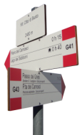
- Trail numbers
G00 + G41
- Time
2h30m
- Level
Intermediate
- Elevation gap
↑ 700m
- Distance
6 km
via Canalone di Morasco:
More challenging trail with steeper parts.
Download the map Download GPS route
- Trail numbers
G00 + G39
- Time
2h10m
- Level
Intermediate
- Elevation Gap
↑ 700m
- Distance
5 km
From Switzerland:
By Car:
Reach the service road of the old Altstafel cableway station on the Swiss-German side of the Nufenen pass. Some car spots are available on the side of the road. Alternatively, reach the top of the Nufenen pass where plenty of parking spots are available. Check the map
here
.
Public Transport:
Reach the railway stations of Airolo (Swiss-Italian side) or Ulrichen (Swiss-German side). Then catch the bus 111 directed to Nufenen pass.
For swiss public transports details,
click here
.
The hike:
From the Swiss side, two options are available to reach the hut. One of them is recommended only to expert hikers. Details below.
via Bettelmatt:
Simple trail with descend towards Bettelmatt Alpine pasture.
Download the map Download GPS route
- Trail numbers
40-G00 + G41
- Time
4h
- Level
Intermediate
- Elevation Gap
↑ 840m - ↓ 420m
- Distance
8.3 km
via Sentiero Castiglioni:
Trail recommended only to expert hikers. Professional show gear might be required to cross steep avalanches chutes.
Download the map Download GPS route
- Trail numbers
40-G00 + G43
- Time
3h20m
- Level
Expert
- Elevation Gap
↑ 690m - ↓ 300m
- Distance
7 km